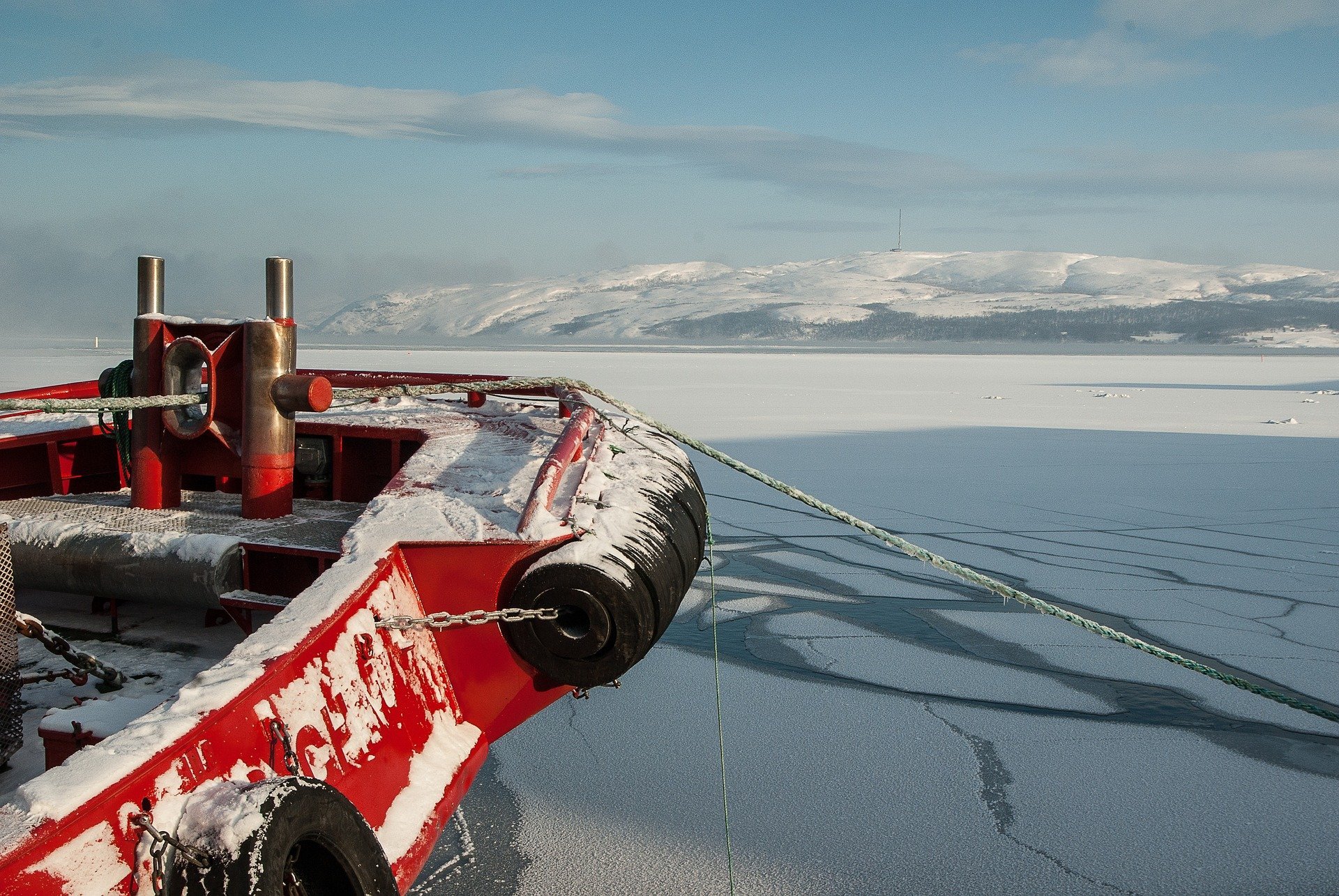
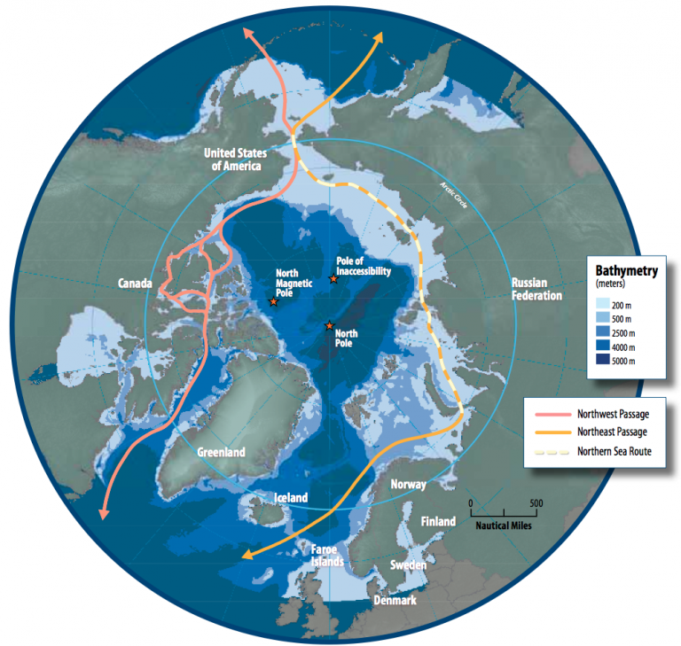
Northwestern Passage NWP welcomes visitors in most of the year, with thick ice layers, complicated gorges and pingos that make sea transportation difficult. Eastern routes Northeast Passage NEP and North Sea Route NSR have higher activity levels than Northwest Passage NWP.
Navigation in NEP, Barents Sea is relatively easier in terms of total ice ratio and open sea. Unlike similar latitudes in Alaska or Canada, the amount of glaciers is lower in this area due to the warm water streams from the Gulf Stream. For both NSR and NEP, sea ice decreases more quickly in summer than NWP area. This feature has become more noticeable since the beginning of the 2000s, due to the records falling. However, in the Laptev Sea and the Kara Sea, where NEP passes, NEP is inaccessible for most of the year, since the risk of not having a minimum pass throughout the year is 17% and 15% respectively.
The Transpolar Sea Route TSR remains a mostly unused route because ships that can pass through are only developed ships, icebreakers, capable of breaking the permanent thick ice layers. In 2010, TSR was only accessible in ice breaker ships in a 10-day period, and this 10-day time is still not considered to be a completely reliable time of period.
Various projections show that the ice mass will be greatly reduced in the future and may even disappear at the end of the century. It is already being monitored that arctic ice is exhausted. The massive ice blocks decreased by 4.3% every ten years on average. However, this decrease is not the same all year round. If we only observed the month of September, the ice floe decreased 10.7% every ten years, but only 2.8% in March. Projection models of arctic ice mass evolution have been based on the past 30 years. These projections mainly use circulation models of ocean and atmospheric currents, such as NEMO, the OGCM and the CMIP. They also take into account the evolution of greenhouse gases, such as CO2.
By 2030, these models estimate that 90% of the current ice area may remain in winter and 60% in September. They estimate that these numbers may drop to 85% and 40% respectively in 2060. Finally in 2090, to 85% in winter and less than 10% in August-September.
As a result of this reduction in ice floe, the number of navigation days on NEP and NWP increases, and roads that are not yet accessible by normal ships such as TSR can be opened. The first is only open for a few days in August and September for now, but some projections show that they will be open for one month in 2030. In 2060, NEP will be open between August and October, and NWP will be open in August and September. Finally, in 2090 both sections will be open for at least three months a year. Some estimates even say that NEP will be available 5 months a year.
However, all these predictions remain uncertain, as the acceleration of global warming and the differentiation of air movements and ocean currents can lead to unexpected results in climatic conditions.
Polar Silk Road - PSR
For the past five years, China has been trying to put its diplomatic and economic stamp on the North Pole since 2018, with the so-called 'Polar Silk Road' method. The innocent and practical basis of this road is associated with connecting the Pacific Ocean to the Atlantic Ocean in less time consuming way by making less voyage from the north, which has become increasingly warmed due to global warming and arctic melting. Making it suitable for sea trade with softer climatic conditions, to establish infrastructure and contribute to the development of maritime trade through other new projects.
The success of PSR does not only depend on the financing and logistics of its various components, it also depends on how the potential political thought between the polar states, who are also in the position of building blocks, has developed.
In the first few years since the Chinese government announced the first steps to build the project, known as the Belt and Road Initiative BRI, in 2013, the North Pole started experiencing climate change and ice erosion. This way to make natural conditions more favorable, PSR would be added on top of the various projects and investments along with Africa, Europe and Eurasia as a key component of the advanced economic partnerships Beijing wanted to develop.
China began to quietly build its Arctic diplomatic policies. Until a few years ago, China took a 'wait and see' approach to connect the North Pole with Belt and Road. In fact, there were signs that China's North Pole would be added to the BRI repertoire. BRI is one of Beijing's projects aimed at achieving a priority for economic diplomacy.
The North Pole for China may not only represent a potentially lucrative shipping route, but can also be considered that China likes to play a role in the renewable energy and green technology industry in the Scandinavian region.
Greater clarity on how PSR would fit on the larger BRI network has been achieved through the publication of Beijing's Arctic Policy. Beijing outlined the scientific and economic interests it planned to develop in the north.
Expressing that she hopes to work with all parties to build a PSR by developing Arctic shipping routes, China has encouraged its investors to study in legal commercial trials to open up commercial and regular shipping operations for these routes.
As the PSR continues to evolve, it is undeniable that what China is seeking is to introduce markets for Chinese goods, investments and technology, and like to integrate with the BRI project, including major regional advanced diplomatic ties. The shortest Arctic seaway between China and Europe is in the north of Siberia and due to its various economic-political cooperation, Russia is by far the leading beneficiary of PSR policies.
Most of the economic agreements on PSR between China and Russia have been in the energy sector due to the Yamal Liquefied Natural Gas (LNG) project, supervised by the Russian company Novatek (НОВАТЭК) in Western Siberia.
Beyond energy, relating to PSR, potential Russian Arctic infrastructure projects took Chinese attention. However, the situation related to the COVID-19 virus and the closure of the Sino-Russian border could disrupt the new Arctic cooperation, at least in the short term.
The situation of PSR countries outside Russia is complicated. The only state that has officially logged in to BRI is Moscow. The United States, especially under its current government, is unlikely to be compatible with BRI, and America's attempts to create an alternative to BRI have been going on for a long time. States such as Canada, Sweden, Finland, Iceland, Norway want to maintain bilateral relations with Beijing, but are exposed to US raids. There are many existing and potential giant projects in the region such as construction, railway, technology, energy, pipeline, and maritime, which will cause technological, economic and strategic concerns that concern many sectors in which China is interested and involved. The decisions to be made by countries are beyond simple and independent business decisions. Three of the countries that are the interlocutors of the project are the powers that are the first three biggest in the world.
Despite the misunderstanding and conflicts, PSR policies are likely to continue and maritime transport is central to China's PSR interests. What is important in this case is whether Beijing can manage the economic diplomacy needed to continue to play a role in the construction of this glacial road and whether it is aware of the political storms that appear and will arise in the region as the general interests of the Arctic Region continue to expand and deepen.